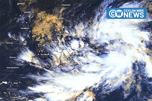
The Meteorology Department has reported that a depression over the southwest Bay of Bengal, located near latitude 10.3°N and longitude 85.3°E at 11:30 p.m. on Friday (Dec. 01), is approximately 490km northeast of Trincomalee. Forecasts suggest that the depression is likely to intensify into a deep depression within the next 12 hours and evolve further into a cyclonic storm by tomorrow (Dec. 03). The system is anticipated to move west-northwestward, approaching the North coast of Sri Lanka and heading towards the North Tamil Nadu coast of India by Tuesday (Dec. 05).
In the weather forecast for today, the Meteorology Department predicts cloudy skies over most parts of the island. Showers or thundershowers are expected at times in the Northern, North-central, Eastern, and North-western provinces, with heavy showers exceeding 100mm likely at some locations. Other provinces may experience showers or thundershowers after 1:00 p.m., with rain expected in the Southern and Western provinces in the morning.
The department warns of strong winds, reaching about 40-50 kmph, intermittently affecting the Northern, Northcentral, Northwestern, and Southern provinces, as well as Trincomalee and Batticaloa districts. The public is advised to take necessary precautions to minimize damages from temporary localized strong winds and lightning during thundershowers.
Sea Areas Under Caution:
Due to the depression in the southwest Bay of Bengal, sea areas extending from Mannar to Pottuvil via Kankesanturai, Trincomalee, and Batticaloa are considered dangerous for activities. Naval and fishing communities are advised to refrain from venturing into these areas until further notice.
Communities engaged in activities in the sea areas off the coast from Galle to Pottuvil via Matara are cautioned to exercise caution. They are also urged to stay informed about future forecasts from the Meteorology Department.
Showers or thundershowers are expected at times off the coast extending from Puttalam to Galle via Mannar, Kankesanturai, Trincomalee, Pottuvil, and Hambantota. Winds will be north-westerly or westerly at 30-40 kmph around the island, increasing to 60-70 kmph off the coast extending from Mannar to Pottuvil and 50-60 kmph off the coast extending from Galle to Pottuvil via Hambantota.
The sea areas from Mannar to Pottuvil via Kankesanturai, Trincomalee, and Batticaloa are expected to be very rough at times, while the sea areas from Galle to Pottuvil via Hambantota may be rough intermittently. Other sea areas around the island may be fairly rough at times. Temporary strong gusty winds and very rough seas are anticipated during thundershowers.